|
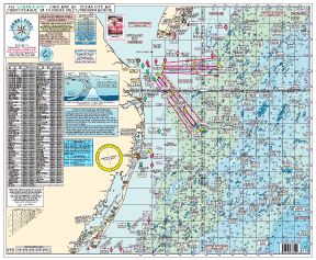
#15 - Cape May, NJ to Ocean City, MD to Chincoteague, VA to Rudee Inlet (Virginia Beach)
"TUNA GROUNDS" - ALL DEPTHS IN FATHOMS - GPS & LORAN
Fishing Grounds:
Sea Isle Ridge, Five Fathom Bank, NE Lump, Middle Lump, East Lump, North Dump Site, Elephant Trunk,19 Fathom Lump, South Dumpsite, Massey's Canyon, Chicken Bone, South Paw, Ham Bone, Twenty Fathom Fingers, Hot Dog, Hot Dog Notch, Jack's Spot, The Sausages, Hot Dog Bun, Mike's Hump, Parking Lot, 16 Mile Hill, Peanut, 21 Mile Hill, Lumpy Bottom, Sea Gull, 26 Mile Hill, Rock Pile, Washington Canyon, Poorman's, South Poorman's, Norfolk Canyon, Middle Finger, First Finger and more.
Wrecks Shown:
Varanger, Bass Barn, Champion, Ammo Wreck, Misty Blue, J.Jones (bow), J.Jones (stern), Lori Dawn, Northern Pacific, Cherokee, Bimbo, Gun Boat, Manhattan, TJ Hooper, Patty's Pitcher, Hvoslev, Capt. Starns, Miss Arlene, Saitia, Muff Diver, San Gil, GS Cook, P. Russell, Boiler Wreck, Atlantic Mist, Hermod Light Ship, Hans, Marine Elec, Olinda, Ammo Ship, Monroe, Queen, Edna, JW Star, Schooner, Patty B, Madrugada, 53 Fa Wreck, U-III Sub, Ostfriesland, Sand Stone, Lawson, Ocean Venture, Vicky, Deco, 44 Fa Wreck, BA Van Brunt, Isabella Paramenter,Clammer, Eureka, Prince of Peace, Nancy, Jennings, 747 Airplane, Spring Chicken, Tercil, Cayahoga, Luchenbach, J Morgan, Clark, Ricks, Stanchion, Gulf Hustler, and more.
* laminated - waterproof
* color coded depth & contour curve lines
* Awesome bottom structure showing holes, shoals, humps and peaks
* wrecks listed in both GPS and Loran
Joins charts: #1 Delaware Bay
#2 Beach Haven to Cape May, NJ to Fenwick Island, DE
#3 All Canyons Hudson to Norfolk
#10 Tuna Chart - Barnegat to Cape May, NJ to O.C., MD
#12 Canyons - Hudson to S. Poormans
|