#22 ICW MANASQUAN INLET-BARNEGAT BAY-MANAHAWKIN BAY
Great for Kayakers!
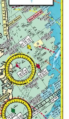
Shows: Manasquan Inlet to Metedeconk River with an enlargement of Bay Head Harbor, then on the ICW, from Mantoloking past Kettle Creek and Silver Bay, Tom's River, and Cedar Creek to Tices Shoal, then past Forked River, Oyster Creek Channel, Double Creek Channel to Manahawkin Bay to Little Egg Harbor
*Unmarked channel north of Myers Hole from Barnegat Inlet to Double Creek Channel highlighted
*Clearly marked buoys, daymarkers lighted markers shown
*Fish speices to target in their habitats are shown
*Holes and Peaks are clearly marked
*Bridges with their Vertical clearances shown
*Marina and boat ramps shown
*Color coded depth and contour curve lines
*Laminated-waterproof
*Crabbin' Spots!
Joins Charts #6 Mud Hole Chart-Sandy Hook to Ocean City NJ
#7 Manasquan to Great Egg Inlet out 20 miles
#10 Tuna Chart-Barnegat to Ocean City MD
#11 ICW Barnegat-Beach Haven-Atlantic City- Ocean City &
Mullica River
#16 Inshore Shark River-Manasquan-Barnegat Inlets
|