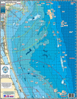
#49 Cape Canaveral to Ft. Pierce, Nearshore
"KINGFISH SERIES"
Bait Spots, Run & Gun
Shows nearshore Wrecks & Reefs and Fishing Grounds with their GPS LAT/LON coordinates for:
Mohican, 100'Sailboat, Steele Barge, 140 Reef Balls, Ocean Venus, Lead Wreck, Damocoles, Tiger Red, Barge, Sufix 1, Titan Reef, Hummingbird Reef, Sphere, 21 Fathom Wreck, Shelby Lee, Port Canaveral #1, Liberty Wreck, Korsholm, Scallop Boat, Noah Smith, Naui #1, Grant Pines, Owens Wreck, SISA #1, #2, #3, County #4, Miss Anita, FPL/FIT Reef, Steel Tanks, RR Ties, Pilot Boat, Barber Bridge, Amazon, Beverly M, North Pelican Flats, North Ridge, Dwyer's Flats, Inshore Bar, Flats Central, Seaman's Big Drop, South Pelican Flats, North 60' Bar, The Pines, 59' Hump, South 60' Bar, North of Thomas, 69 Hump, South 90' Bar, Middle Bar, Thomas Shoal, Wabasso Rocks, Drop Off, 60' Lump, 57' Lump, Offshore Bar, North 5 Mile Reef, Fishing Club Reef, Pierce Shoal, The Boil, St. Lucie Shoal, NW Reef, Indian River Shoal, Twin Peaks.
* Shows local bait spotsboth shallow and deep
* Color coded depth and contour curve lines
* Laminated-waterproof
* 5 mile radius lines from Port Canaveral, Sebastian, & Ft. Pierce Inlets
* All depths in feet
Joins Charts: #36 Sebastian- Ft. Pierce- St. Lucie Inlets out 20 miles
#39 Ponce de Leon- Port Canaveral- Sebastian Inlets Offshore
#45 ICW Indian River from Vero Beach to Hobe Sound
#40 Upper Bahamas
#29 Kingfish Chart Nearshore Ponce to Canaveral to Sebastian Inlets
#48 Northern Swordfish Chart
|